This is the adventure and volunteerism log for Matthew Dexter Edmonds, aka "Treeman." Aside from Blogger comments, contact information is listed on Google+. And all places mentioned in this log are in the State of Ohio in United States of America unless otherwise stated. "The Wayne" = the Wayne NF.
Also, the motorhome mentioned is a 25ft, 1988 Itasca Sundancer, Model IF424RC with a Ford Econoline cutaway unless otherwise stated. It runs a 351 Windsor EFI V8 engine.
Search This Blog
2016/02/17
Log 2016021701
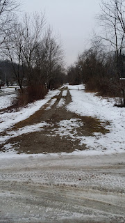
This is a look at the American Discovery Trail - West Virginia concurrent with the North Bend Rail Trail @ 39.210312, -81.513641 on Tuesday, February 16th, 2016. As far as snow goes, this isn't the best that this area can do by any means. But the area is approximately 20 miles south of the Whipple and about 40 miles SE of the Stockport Sections - Buckeye/ North Country Trail in SE Ohio. With this picture being taken near the West Virginia University - Parkersburg, it goes to show that it does snow in SEO.
On the Whipple Section, most of the township roads had nearly solid sheets of hard packed snow. My Chevy HHR couldn't make it traveling CW/ Wb couldn't make it up the section tallest on-road gain between Points 18 & 19 (10/2010 map & guide). I was convinced to quit smoking once because of this hill. It got about 20 feet from the top near Darrah Ridge Rd/ T10 before I had to back it down and "Austin Powers" it the other direction. "Austin Powers" refers to the part in one of the movies when he had to turn a lengthy golf cart around in a narrow tunnel. Sometimes, that's what it's like.
Subscribe to:
Post Comments (Atom)

No comments:
Post a Comment